
Here at UASci, we specialise in Dynamic Drone Systems for a wide variety of Industries and Applications
Join Venture Announcement
Between Aquila Australia and UASci Ltd
May 2023
UASci Ltd is pleased to announce that after many months of discussions we have entered into a Joint Venture with Aquila Australia with the Joint Venture being named ‘Aquila UAS’.
We have moved the Kestrel UAV and equipment from Perth WA to Kurnell NSW where Aquila Australia has a clean lab and support services close at hand.
Aquila’s Raven UAV will be developed alongside the larger Kestrel for operations suited to their capabilities.
Exciting times.
Aquila UAS
Address: Factory 1/260 Captain Cook Dr.
Kurnell NSW 2231
Phone: 02 9668 9111

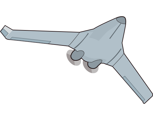
KESTREL 1

Maximum Altitude: 16,000ft
Average Range: 1,780km
Wet Weight: 150kg
Wingspan: 6m
Payload: 30kg
MILITARY GRADE COMPONENTS
![]() Alert Transponder & Anti-Collision System
Alert Transponder & Anti-Collision System
![]() Autopilot & Navigation System
Autopilot & Navigation System
![]() Satellite Link & Radio Downlink
Satellite Link & Radio Downlink
![]() Flight Duration: 12 hours (Not limited by Pilot Fatigue)
Flight Duration: 12 hours (Not limited by Pilot Fatigue)
![]() Multi-Spectral, Thermal, Video and Still Cameras
Multi-Spectral, Thermal, Video and Still Cameras
KESTREL 1A & 2
Maximum Altitude: 16,000ft
Loiter Speed: 70 km/h
Transit Speed: 150+ km/h
Average Range: 1,780km
Wingspan: 6m
Payload: 30-60kg
Wet Weight: 150kg
MILITARY GRADE COMPONENTS
![]() Alert Transponder & Anti-Collision System
Alert Transponder & Anti-Collision System
![]() Autopilot & Navigation System
Autopilot & Navigation System
![]() Satellite Link & Radio Downlink
Satellite Link & Radio Downlink
![]() Multi-Spectral, Thermal, Video and Still Cameras
Multi-Spectral, Thermal, Video and Still Cameras
![]() Flight Duration: 12 hours (Not limited by Pilot Fatigue)
Flight Duration: 12 hours (Not limited by Pilot Fatigue)
![]() Twin Engine Design – Provides engine redundancy
Twin Engine Design – Provides engine redundancy
OSPREY
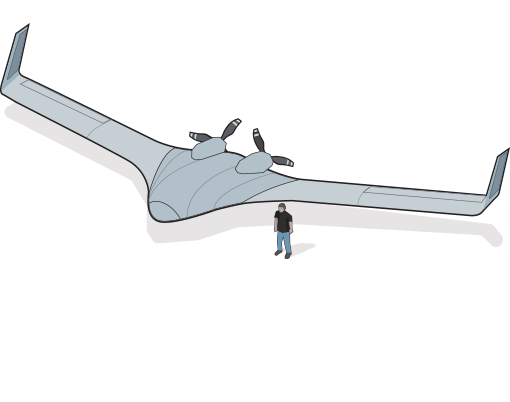
Maximum Altitude: 25,000ft+
Transit Speed: 330 km/h
Average Range: 10,000km
Wingspan: 18m
Payload: 400kg
Wet Weight: 2,200kg
MILITARY GRADE COMPONENTS
![]() Alert Transponder & Anti-Collision System
Alert Transponder & Anti-Collision System
![]() Autopilot & Navigation System
Autopilot & Navigation System
![]() Satellite Link & Radio Downlink
Satellite Link & Radio Downlink
![]() Multi-Spectral, Thermal, Video and Still Cameras
Multi-Spectral, Thermal, Video and Still Cameras
![]() Twin Engine Design – Provides engine redundancy
Twin Engine Design – Provides engine redundancy
APPLICATIONS
![]()
Fire Control & Monitoring
Deployment of incendiary devices, fire surveillance dawn to dusk. Photography below cloud cover.
![]()
Exploration
Geophysical surveys; magnetics and radiometric. Gold. Imagery, geological mapping, interpretation, exploration targeting.
![]()
Smart Farming
Monitoring vegetation, water resources, livestock numbers including ocean stocks. Monitoring/control of feral animals, aerial baiting.
![]()
Oceania
Coastline mapping, coastal surveillance, search and rescue, shipping security.
![]()
Scientific
Measuring/monitoring atmospherics and climate change.
![]()
Wildlife Conservation
Monitoring animals and reserves under threat & aerial baiting (patent pending).
![]()
Military
ISR Missions. Resupply.
![]()
Disaster Response
Aerial surveillance, mapping, interpretation and response plans. Over watch of response personnel. Aerial delivery of essential items.
MANAGEMENT TEAM

The key management/staff team are professionals in their own right and are capable of delivering innovation and service levels demanded by the target consumer in all areas of design and development.
The senior management and key personnel of UASci are:
- Managing Director & Chairman: Paul Denne
- Director: Spero Carras
- Director: Fernando Urrutia
- Company Secretary: Paul Denne
- Design Engineers : Spectro Pty Ltd – Thomson Design